


Little India is often sold as a quick sensory hit: garlands, gold shops, biryani, bright temples. But the National Heritage Board’s Little India Heritage Trail tells a more layered story of Serangoon Road as a working district shaped by cattle yards and a racecourse economy, early cottage industries, migration, shophouse commerce, and a dense patchwork of faiths. It also makes a point that matters for understanding the precinct today: Little India was never only Indian. Chinese and Malay businesses operated here alongside Indian communities, and that mix helped form the commercial heartbeat you experience now.
Before You Start: timing, comfort, and what this route is (and isn’t)
This self-guided walk is built as a practical, condensed version of the National Heritage Board’s Little India Heritage Trail, which spans more than 40 heritage sites over roughly four kilometres and is organised into three themes: Serangoon in the 1900s, Walk of Faiths, and Shop Till You Drop. Instead of trying to “collect” everything, this route cherry-picks the highest-value stops that best explain the big ideas NHB emphasises: cattle and the racecourse economy, early industries, migration, shophouse life, religious diversity, and the evolution into today’s Indian commercial district.
Plan for 2 to 3 hours at an easy pace with pauses for photos, a drink, or a quick museum stop. The full route is about 3.2 to 3.8 kilometres depending on detours inside arcades and lanes, and it’s mostly flat. Start at Little India MRT (Exit E is the most convenient for Campbell Lane and the Indian Heritage Centre area). End at Farrer Park MRT for a clean finish near Serangoon Road’s northern stretch.
Best walking hours are early morning (roughly 8:00 am to 10:30 am) when the streets are active but not yet at their hottest, or late afternoon (about 4:30 pm to 7:00 pm) when light improves for photos and the area shifts into dinner mode. Midday heat can feel intense on exposed segments of Serangoon Road. Shade comes and goes: you will get relief under shophouse five-foot ways on side streets like Campbell Lane and Dunlop Street, but some stretches are sun-exposed.
For toilets, your most reliable, low-stress options are Tekka Centre (market and hawker centre complex) and the Indian Heritage Centre if you decide to go inside. Bring a small umbrella for sun or sudden rain, wear footwear you can walk in for a few kilometres, and pack a light layer if you plan to step into air-conditioned spaces after being outside.
The 2 to 3 hour NHB-inspired route (start and end points, distance, and flow)
Start: Little India MRT (Exit E) to Campbell Lane. End: Farrer Park MRT. Distance: approximately 3.2 to 3.8 kilometres, depending on how much you wander within Tekka and the side lanes. Pace: relaxed walking with short stops, 2 to 3 hours.
This route is designed to unfold like a story. You begin at the Indian Heritage Centre exterior as a “table of contents” for the precinct, move through Campbell Lane and the shophouse grid that powered everyday commerce, then reach the Tekka area where market life and migration patterns converged. From there, you step into Little India’s Walk of Faiths through major places of worship, and finally finish where Serangoon Road’s commercial identity and transport links made it a natural gathering point.
Stop 1 (5 to 10 minutes): Indian Heritage Centre exterior on Campbell Lane. Even if you do not go inside, treat the building as a modern landmark that signals how Singapore narrates Indian heritage today. If you do go in, note the practical detail: the Indian Heritage Centre’s published opening hours are Tuesday to Sunday, 10:00 am to 6:00 pm, with last admission at 5:30 pm, and it is closed on Mondays. That closure can shape your planning if you are walking on a Monday and counting on indoor breaks.
Stop 2 (10 to 15 minutes): Campbell Lane and the surrounding street pattern. Campbell Lane is not just a “cute lane” near a museum. It’s a reminder that Little India’s life was built from narrow streets, back lanes, and shophouse frontages that encouraged small-scale trading and services. Walk slowly and look at how the five-foot way works: it’s shade, it’s pedestrian circulation, and it’s a commercial display shelf. This is also where NHB’s warning against oversimplification becomes real: Little India historically included Chinese and Malay businesses as well as Indian communities, and a shophouse street doesn’t announce one identity only. It announces trade.
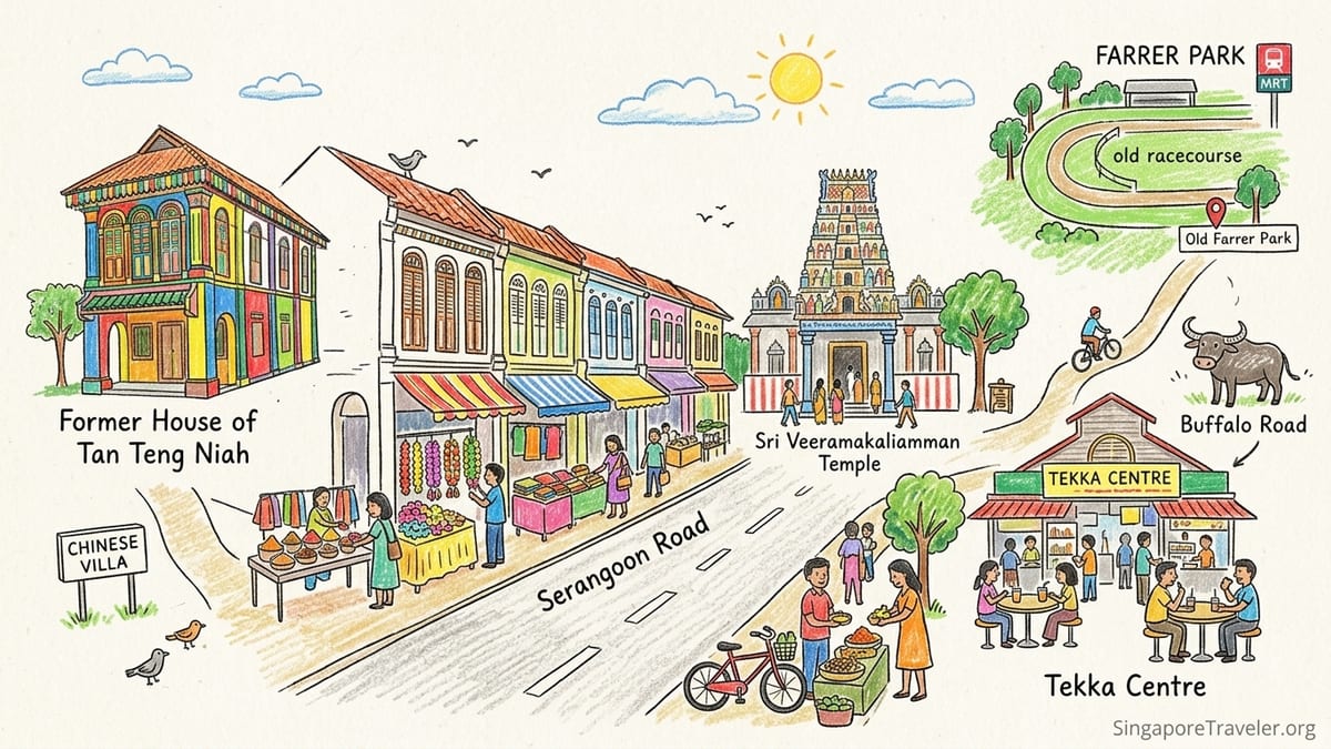
Stop 3 (10 minutes): Former House of Tan Teng Niah (Kerbau Road). This vividly painted villa is famous in photos, but its historical value is sharper than its colour. It is identified on the heritage trail as Little India’s last Chinese villa, tied to a period when Chinese cottage industries operated here alongside the Indian-dominated cattle trade. In other words, this one building helps you hold two truths at once: the district became a core Indian enclave, and it still carried other communities’ work and property in the same urban fabric.
Stop 4 (25 to 40 minutes): Tekka area, including Tekka Centre and its immediate streets. Tekka is where your walk touches the long arc from rural edges to modern city. The area’s older identity is embedded in names like Buffalo Road and Kerbau Road (kerbau means buffalo), and in how market activity fed everyday life. Today, Tekka Centre is a practical stop as well: toilets, drinks, and a place to experience the smells and sounds that made Serangoon Road a magnetic corridor. If you want a concrete, low-risk snack strategy, this is where you can buy a bottled drink, a fresh juice, or an inexpensive hawker meal without committing to a long sit-down restaurant stop that eats into your walking time.
Stop 5 (10 to 15 minutes): Serangoon Road shophouse stretch and Little India’s commercial spine. From Tekka, orient yourself on Serangoon Road as one of Singapore’s earliest roads and the district’s main spine. What you see now, textiles, goldsmiths, electronics, groceries, restaurants, sits on top of older layers: farms along the road in the early decades, the racecourse economy, and then a cattle trade that drew workers and entrepreneurs into the neighbourhood. Even if you don’t have the original maps in hand, you can read the street as infrastructure: it is wide enough to carry traffic, connected enough to pull customers, and lined densely enough to support retail clustering.
Stop 6 (10 to 15 minutes): Sri Veeramakaliamman Temple (Serangoon Road). You do not need to turn this into a temple “review” to make it meaningful. Stand across the street first and watch the flow of shoes-off visitors, flower garlands in hand, and passing traffic. This temple is a strong example of how the growth of an Indian population in the late 19th and early 20th centuries expressed itself physically: religious and cultural landmarks became anchors, not just for worship, but for daily orientation in a busy commercial district.
Stop 7 (15 to 20 minutes): Abdul Gafoor Mosque (Dunlop Street). Turn off the main road and let the environment change. Dunlop Street is where you can feel the “Walk of Faiths” theme as a living neighbourhood rather than a checklist. The mosque, gazetted as a National Monument, underscores a key point for travellers: Little India’s identity is not a single-faith story, and its Indian communities included Muslims as well as Hindus and others. Dress modestly if you approach close, keep voices low, and treat it as a working place of worship rather than a backdrop.
Stop 8 (10 to 15 minutes): Race Course Road and the northern Serangoon Road endgame toward Farrer Park. As you push north, you are walking through the area’s “why here?” logic. The Urban Redevelopment Authority notes that a racecourse was established at what is now Farrer Park in the 1840s, and that later the cattle trade became the main economic activity drawing many Indians involved in cattle and dairy as owners and labourers. That economic pull is part of why Little India cohered here, and it helps explain why the district remained a commercial magnet even after the cattle trade declined and shophouse commerce expanded.
Reading Little India like a historian: cattle, the racecourse, and street names that still talk
Little India’s modern retail energy can make it easy to miss that this was once a working district tied to animals, agriculture, and transport. The Urban Redevelopment Authority describes Serangoon Road as one of Singapore’s earliest roads, linked to early farms and later shaped by major draws like the racecourse at what is now Farrer Park. The racing season brought attention and movement into the area, and even the street names preserve traces of who moved in and why.
Then comes the cattle economy, which URA identifies as the main economic activity that drew many Indians connected to cattle and dairy trading. You can still “see” that era without any museum label: Buffalo Road and Kerbau Road sit beside your walking line like footnotes, and they are not poetic branding. They’re memory. Even Belilios Street and Desker Street, noted by URA as tied to cattle trading figures, read like an index of how commerce once structured the precinct.
This is also where the NHB trail’s nuance matters. The Former House of Tan Teng Niah is singled out as a remnant of the early days when Chinese cottage industries thrived alongside the Indian-dominated cattle trade. That overlap is the antidote to a simplistic “one community, one district” narrative. If you slow down and watch deliveries, shoppers, and worshippers sharing the same pavement today, the old coexistence feels less like a trivia fact and more like the district’s default mode.
When you reach Farrer Park at the end, you are not simply “finishing near another MRT.” You are arriving at an origin point. The racecourse that once sat here helps explain the neighbourhood’s early gravitational pull, and it’s one reason the Serangoon Road corridor developed the capacity to absorb successive waves of workers, traders, and customers.
From early industries to shophouse life: why the five-foot way is part of the heritage
The NHB trail is not just about monuments. It’s about how daily life worked, and shophouses are the engine room for that story. URA’s conservation overview notes that Little India’s shophouse designs span multiple periods, from early styles through transitional forms and even Art Deco-era expressions. You do not need to memorise architectural labels to appreciate the point: this building type allowed commerce on the ground floor and living space above, packing work and home into the same footprint.
On this walk, the most practical place to observe shophouse logic is on side streets and lanes where the five-foot way is uninterrupted. The covered walkway offers shade, but it also shapes business behaviour: stalls spill outward, signage stacks vertically, and small services can survive on foot traffic rather than car access. That is one reason this district still feels intensely walkable and intensely commercial at the same time.
Tekka and the surrounding streets show how a market anchors a neighbourhood’s routine. Even if you do nothing more than walk through Tekka Centre to cool off and buy a drink, you’ll notice how the precinct’s shopping culture is not only about souvenirs. It’s about groceries, spices, textiles, and ready-to-eat food, the everyday items that make a commercial district durable long after any single industry fades.
To keep your own walk grounded and not theoretical, pick one small purchase as your “field note.” It can be as simple as buying a cold bottled water or a takeaway tea from a stall and then observing who else is buying what: office workers grabbing lunch, families carrying market bags, worshippers stopping for flowers. That mix is the heritage in motion.
Walk of Faiths, without the checklist: how diversity became the district’s landmark system
The Little India Heritage Trail’s Walk of Faiths theme is easy to misunderstand as “go to several religious sites.” The more interesting point is why so many places of worship exist so close together and why they became landmarks. URA links the growth of the Indian population in the late 19th and early 20th centuries to the rise of numerous religious and cultural landmarks, and it notes that the area’s diversity is demonstrated by a wide variety of places of worship serving different communities.
Sri Veeramakaliamman Temple, which sits directly on Serangoon Road, is a strong example of visibility: it is hard to ignore, and it doesn’t need a ticket or a timed entry slot. Stand back first, look up, and then notice the street-level reality, worshippers moving in and out while shoppers weave past. In a district that became primarily commercial over time, places of worship did not vanish. They adapted into the flow.
Abdul Gafoor Mosque, located on Dunlop Street, changes the emotional temperature of the walk. It is off the main roar of Serangoon Road, and it signals another key truth: “Little India” is not an exclusively Hindu space, and the Indian story in Singapore includes Muslim communities too. If you are travelling with children or first-time visitors, this is a good place to model respectful travel behaviour: dress modestly, avoid loud conversations, and treat photography as optional rather than automatic.
When you put these stops together, you get a practical heritage lesson: religious diversity is not a side note here. It is a system. These sites oriented residents, supported community life, and remain part of the district’s identity even as tourism and retail have intensified.
How Serangoon Road became today’s Indian commercial district (and why it wasn’t inevitable)
URA is explicit that the Serangoon Road area was never designated by Raffles as an Indian area in the same way that Chinatown or Kampong Glam were associated with other communities. Little India formed through economic pull, migration patterns, and the everyday logic of where work and housing clustered. That matters because it reframes the neighbourhood as something built from repeated choices, not a single colonial decision.
By the 1940s, URA notes the area had become a commercial-residential district with a significant Indian population. Later, during the 1960s and 1970s, many residents moved out and Little India became primarily a commercial centre. The slum clearances of the 1970s and public housing developments such as Tekka Centre and nearby projects in the 1980s reshaped the built environment again. You can feel those layers when you walk: conserved shophouses beside larger modern blocks, long-established businesses beside newer retail formats.
NHB also emphasises a lived streetscape where small traditional businesses operate alongside bigger stores. In practice, that means you can walk past a flower garland vendor, a goldsmith, and a multi-storey retail outlet within minutes. If you want a concrete, time-saving way to experience the commercial district without turning your walk into shopping, give yourself one targeted errand: buy a small box of Indian sweets for later, pick up a spice blend you recognise, or choose a simple meal you can eat quickly, then keep moving. The district’s story is on the pavement, not only in your shopping bag.
Finally, keep the NHB nuance front and centre: Chinese and Malay businesses historically operated here too. That layered history is why the area can hold contradictions comfortably. It is “Little India” in cultural association and commercial concentration, but it is also a Singapore neighbourhood that has always been multi-ethnic and multi-use.
A shorter 60 to 90 minute version (for heat, kids, or tight schedules)
If you only have 60 to 90 minutes, you can still walk a heritage-first line that honours the NHB trail themes. Keep it compact and shade-friendly by focusing on the Tekka area, the Former House of Tan Teng Niah, and one major place of worship. This shortened version is roughly 1.6 to 2.2 kilometres depending on detours.
Start at Little India MRT (Exit E). Walk to the Indian Heritage Centre exterior for a quick orientation, then follow Campbell Lane’s shophouse environment toward Kerbau Road to see the Former House of Tan Teng Niah. From there, head to Tekka Centre to experience the market hub and take a toilet break. If the day is hot, this is where you stop for a cold drink and a quick bite rather than pushing deeper into sun-exposed stretches.
Finish by walking down Serangoon Road to Sri Veeramakaliamman Temple for a brief, respectful look, then loop back to Little India MRT. This keeps your walk inside the densest “story zone” where migration, commerce, and faith sit within a few blocks, without requiring the longer push toward Farrer Park.
If you are walking on a Monday and want an indoor pause, remember that the Indian Heritage Centre is typically closed on Mondays, so treat it as an exterior-only stop and lean on Tekka Centre for practical needs instead.
The Takeaway
A good Little India walk is not a scavenger hunt for photogenic corners. It is a readable, street-level history of how a working district, shaped by a racecourse and cattle trade, turned into one of Singapore’s most dynamic commercial neighbourhoods. The National Heritage Board’s heritage trail themes help you focus on the real drivers: economic ecosystems first, then migration and everyday commerce, and finally the dense religious and cultural landmarks that still structure how the precinct feels.
This 2 to 3 hour route keeps you close to the “high-signal” stops: Tekka as a living market anchor, the Former House of Tan Teng Niah as proof of overlapping communities and industries, Campbell Lane as a shophouse-powered commercial fabric, and the paired experience of Sri Veeramakaliamman Temple and Abdul Gafoor Mosque as a lived Walk of Faiths. Walk it slowly, in cooler hours, and you will leave with something more durable than photos: a sense of why Little India is here, why it changed, and why it still works.
FAQ
Q1. How long is this Little India walking tour and how far will I walk?
Plan 2 to 3 hours for about 3.2 to 3.8 kilometres, depending on how much you wander inside Tekka Centre and nearby lanes.
Q2. Where should I start and end the route by MRT?
Start at Little India MRT using Exit E for Campbell Lane. End at Farrer Park MRT for a straightforward finish along Serangoon Road.
Q3. What are the best hours to walk Little India to avoid the worst heat?
Go in the morning roughly 8:00 am to 10:30 am, or late afternoon about 4:30 pm to 7:00 pm for better light and less heat stress.
Q4. Is there shade on the route?
Some stretches are shaded under shophouse five-foot ways, especially on side streets like Campbell Lane and Dunlop Street, but parts of Serangoon Road can be sun-exposed.
Q5. Where can I reliably find toilets during the walk?
Tekka Centre is the most dependable mid-walk option. If you go inside, the Indian Heritage Centre is another practical stop for a restroom break.
Q6. Is the Indian Heritage Centre open every day?
No. It generally operates Tuesday to Sunday from 10:00 am to 6:00 pm with last admission at 5:30 pm, and it is closed on Mondays.
Q7. What’s the single most important stop if I can only choose one?
Tekka Centre and its immediate streets are the best all-in-one stop because they connect market life, migration patterns, and today’s everyday commercial rhythm.
Q8. How do I experience the “Walk of Faiths” respectfully?
Dress modestly around places of worship, speak softly, and treat photography as optional. Remember these are active religious spaces, not just sightseeing points.
Q9. What is the shorter 60 to 90 minute version of this tour?
Do an exterior look at the Indian Heritage Centre, walk Campbell Lane to the Former House of Tan Teng Niah, continue to Tekka Centre for a quick market pass-through, then see Sri Veeramakaliamman Temple before looping back to Little India MRT.
Q10. Is Little India historically only an Indian neighbourhood?
No. NHB’s heritage framing notes that Chinese and Malay businesses were present historically alongside Indian communities, which is key context for understanding the district’s layered identity.